
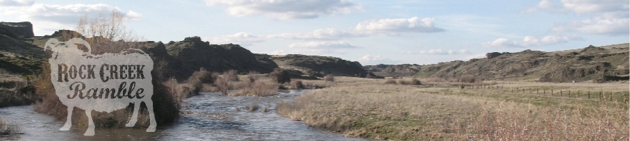
4/12 - Rock Creek Ramble 30k, 50k & 100k
NEW Half Marathon!

Rock Creek Ramble takes place at Escure Ranch, in the beautiful channeled scablands of Eastern Washington. The course will tour the valley and basalt mesas surrounding Rock Creek, with breathtaking views of the creek, basalt cliffs, marshes, and vast expanses of rolling grassland at this mid-20th-century sheep and cattle ranch.

Course options include 100k, 50k, and 30k, with the 100k runners making two complete tours of the 50k route.
The terrain is generally flat-to-rolling but is punctuated by basalt mesas providing short, sometimes steep climbs.
The climb per course is:
- Half Marathon (21k): 980 feet
- 30k: 830 feet
- 50k: 1810 feet
- 100k: 3620 feet
Here is a PDF of the route. You can also get a sense of this beautiful terrain by watching this video of 2013's Rock Creek Ramble Navigation Race that was also held in the scablands near Sprague.
The time cut-off for the 100k will be 16 hours (15:27 min. per mile pace). The cut-off times for the Half Marathon, 30k and 50k have not been determined yet, but they will be generous, since staff will be there all day to support the 100k runners.
ROCK CREEK DOUBLE

Make it a "Rock Creek Double" by participating in the Rock Creek Ramble Navigation Race the next day! Choose 4, 7, or 10 hours to find as many checkpoints as you can. Checkpoints are marked on a USGS topographic map; when you arrive at a checkpoint, you'll find a numbered orange flag, and a unique pinhole punch to punch your card to prove that you wre there. The route you choose is up to you, but GPS is not allowed! Just old school map-reading skills, and a trusty compass. Participate solo, or in teams of 2-5! Those that complete the Rock Creek Double will receive a special straw trucker hat with hand-painted event artwork!
PRICING
SUPER EARLY / EARLY / REGULAR / DAY-OF-EVENT
Half: $41 / 46 / 51 / 60
30k: $44 / 49 / 54 / 6550k: $56 / 61 / 66 / 75
100k: $77 / 82 / 87 / 100
Super Early prices ended January 31st, 11:59pm
Early prices ended February 18th, 11:59pm
Regular prices end April 9th, 11:59pm
Day-of-event registration is available. We can accept payment by cash or check payable to MerGeo or Northwest Trail Runs.
Schedule:
Friday, April 11:
6:00-8:00 p.m. check-in open at race site
camping open at start Friday night
Saturday, April 12:
5:30-5:45 a.m. - 100k check-in
6:00 a.m. - 100k start
6:45-7:45 a.m. - 50k check-in
8:00 a.m. - 50k start
8:30-9:15 a.m. - Half Marathon and 30k check-in
9:30 a.m. - Half Marathon and 30k start
6:00 p.m. - Half Marathon, 30k, and 50k cut-off
10:00 p.m. - 100k cut-off (16 hours, 15:27/mile pace)
Aid Stations:
There are numerous water-only points along the course, in addition to the three fully-stocked and staffed aid stations (shown in bold type below), one of which is at the start/finish point and is visited between loops. The approximate aid station distances are:
- Half Marathon: 4.6 mi (full aid), 9.1 mi (water only), 11.4 mi (water), 13.1 (finish)
- 30k: 4.1 mi (water), 6.8 mi (water), 7.4 mi (full aid), 10.2 mi (water), 13.9 mi (water), 17.2 mi (water), 18.9 mi (finish)
- 50k: 4.1 mi (water), 6.8 mi (water), 7.4 mi (full aid), 10.2 mi (water), 13.9 mi (water), 17.2 mi (water), 18.9 mi (full aid), 23.5 (full aid), 27.9 mi (water), 30.2 mi (water), 31.9 miles (finish)
- 100k: 4.1 mi (water), 6.8 mi (water), 7.4 mi (full aid), 10.2 mi (water), 13.9 mi (water), 17.2 mi (water), 18.9 mi (full aid), 23.5 (full aid), 27.9 mi (water), 30.2 mi (water), 31.9 miles (full aid), 36.0 mi (water), 38.7 mi (water), 39.3 mi (full aid), 42.1 mi (water), 45.8 mi (water), 49.1 mi (water), 50.8 mi (full aid), 55.4 (full aid), 59.8 mi (water), 62.1 mi (water), 63.8 miles (finish)
The aid stations will have water, electrolyte drink (HEED and Vitalyte), Endurolytes capsules, and a variety of carbohydrate-rich and salty foods, such as energy gels, cookies, pieces of energy bar, boiled potatos, chips/pretzels, bagels, fruity candy, fig bars, peanut butter and jelly sandwiches, bananas, oranges.
Thanks to Hammer Nutrition for providing Hammer HEED, Hammer Gels, and Endurolytes!
![]()
Fence Crossings:
There are a number of fence crossings on the course. To get everyone over the fences safely and comfortably, we've built sturdy stepladders to cross them.
Course Markings:
There are a few places where the route goes briefly off-trail, so we've made some extra-visible-extra-tall course markings to keep you on track.

Driving Directions:
Allow about 5 hours driving time from SeaTac Airport or Seattle (more during heavy traffic times or poor weather), 1.5 hours from Spokane, 6 hours from Portland, or 7 hours from Vancouver, BC. Here are links to weather conditions along I-90, the Snoqualmie Pass (on I-90) report, and Seattle-area traffic.
- Follow I-90 to Sprague, WA
- Take exit 245, and go South on State Route 23
- After 12.3 miles, turn right at Davis Road
- After 7 miles, turn left onto Jordan Knott Road (about 0.8 miles after you cross the John Wayne Pioneer Rail Trail, 800m after passing a grain elevator, and 200m before a sharp right bend to the North)
- After 2.2 miles, take the right fork to leave Jordan Knott Road where it veers left
- Go 2.5 miles, following the road down the hill to the Rock Creek Recreation Site, adjacent to Rock Creek
- Park according to the pre-event bulletin or as directed by staff or event signs. Primary parking is to the side of the road or in the camping and parking area to the North.
Parking, check-in, start, and finish will be at Rock Creek Recreation site. Here is a link to a map of the location. There are pit toilets but no running water, so if you would like to wash off, then please bring your own for before and after the event.
Register!

![]()


![]()

Buy NWTR Apparel!
$20
at RunningBug Apparel

Theme by Danetsoft and Danang Probo Sayekti inspired by Maksimer