You are here

Error message

  • Deprecated function: The each() function is deprecated. This message will be suppressed on further calls in _menu_load_objects() (line 569 of /home/659802.cloudwaysapps.com/kfemuxkttj/public_html/includes/menu.inc).
  • Deprecated function: implode(): Passing glue string after array is deprecated. Swap the parameters in drupal_get_feeds() (line 394 of /home/659802.cloudwaysapps.com/kfemuxkttj/public_html/includes/common.inc).

Lord Hill

REGISTRATION OPEN!

Lord Hill Trail Run

Sunday, July 27, 2014, 9:30 a.m.

Lord Hill Trail Runner

For those looking for a hilly race, Lord Hill Regional Park is a great choice!  The course starts at the south end of the park and immediately spreads out the field with a respectable climb!  From there, the course meanders through mossy forests, along tranquil ponds, creeks, and wetland preserves.  The course itself is a combination of single-track, old logging road, maintained hiking path and a few bridges for good measure.  It’s a very diverse course!  Boredom is not an option at Lord Hill!

There are two course options for this event:

  • 10K (exact distance is 9.79km, or about 6.1 miles), with about 1080 feet of elevation gain*
  • Half Marathon (21.10 km, or 13.1 miles), with about 2080 feet of elevation gain*

Both the 10k and Half Marathon courses start and finish near the Snohomish River at the South end of the park. The routes are fairly hilly, with a mix of steep and moderate grades, as well as some flatter sections. These courses are moderately hilly by trail running standards. Both courses include a mix of wider and narrower trails, with the Half Marathon having more of the smaller trails. Most of the trails are not very twisty, but there are some parts with more twists and turns on the Half Marathon course.

* Distances were measured using a measuring wheel or a bicycle odometer. Climb was measured from the map, and should be considered approximate.

2013 Results


PRICING

SUPER EARLY / EARLY / REGULAR  / DAY-OF-EVENT 

10k: $27 / $30 / $34 / $40

Half Marathon: $34/ $39 / $43 / $50


Super Early registration prices end Wednesday, December 25th at 11:59pm.                                                                                                                                                                                                                                                       Early registration prices end Saturday, June 25th at 11:59pm.

Regular pre-registration prices end Friday, July 25th at 11:59pm.

Day-of-event registration is available. We can accept payment by cash or check payable to MerGeo or Northwest Trail Runs.


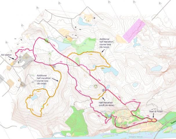
The 10k and Half Marathon courses share the same route to start with. After a few hundred meters of flat running, the route climbs steeply through about the first mile, at which point it drops again before climbing more moderately. At 3.8 km, there is a junction where the 10k runners continue straight to the aid station at 5.06 km. Half Marathon runners turn sharply left at this junction and run an additional 2-mile lollipop loop (an out-and-back section on West View Trail with a hilly, nearly mile-long loop at the end), before rejoining the 10k loop and continuing to the aid station at 8.27 km.

The aid station is at the end of a 1/3 mile out-and-back along a fairly wide trail, and after this out-and-back, the 10k course returns to the pipeline trail and then fairly directly back to the finish, except for two side trips to pick up some nice, smaller forest trails. The course drops sharply over the final 1.2 km, including nearly 400 feet of elevation loss.

The Half Marathon course shares most of the 10k route, except with a single added trip around the West View Trail lollipop loop, a side trip around the Temple Pond Loop that splits from the 10k route 1.7 km after the aid station, and with another loop of the Northern part of the course, including the aid station and the Temple Pond Loop. After the second time around the Temple Pond Loop, the Half Marathon course returns to the finish along the same route as the 10k.

There are three trail junctions where the 10k and Half Marathon courses go different ways, and these will be clearly indicated.

Aid station

There will be one aid station. It will be visited by the 10k runners 5 km into their course. The Half Marathon runners will visit the aid station twice, at the 8.27 km and 15.29 km points of their course.

The aid station will have at least water and some sort of carbohydrate-rich food, such as pieces of bagel, fig bars, cookies, fruity candy, and/or bananas. There will likely be a few choices of these foods, along with Vitalyte electrolyte replacement drink.

Safety and Trail Etiquette

The trails will be open to other users during the event, including pedestrians, mountain bikers and equestrians (horseback riders). Please be courteous. Horses have the right of way, and if you encounter a horse in your path, stop running and talk to the rider; you will probably need to step to the side of the trail to let the horse past, but sometimes the rider will tell you it is okay to walk past. It is unlikely that there will be much trail traffic, but if the weather is nice, you will almost certainly encounter some others.

In places, the trails have sharp turns, bumps (rocks or tree roots), and holes, and it pays to pay attention to where you put your feet in such sections. However, none of the trails are treacherous or demand any special skills or experience to navigate them. Anyone who is fit enough to hike or run the distance should be able to get through the course fine with a bit of care.

At about 1.2 km (3/4 miles) into the run, there is a creek crossing that requires taking a few steps on rocks and logs. They could be slippery if they are wet, and we recommend slowing to a walk and taking extra care at this point. This will be after most of the initial steep climb, so you may feel like walking, anyway. (It is unlikely that you will get your feet wet here, since the rocks and logs are covering up the trickle of water underneath.)

Participants are responsible for their own safety while participating, and the organizers are neither qualified nor equipped to render medical care in the event of a serious injury. In case of an emergency, call 9-1-1. You are encouraged to bring a cell phone with you as a safety precaution, if you wish.

Where the trails are narrow, please let other participants pass you if they want to get by. It is a passing runner's job to tell the person in front that they wish to pass.

Two days before run

11:59 p.m.    Pre-registration closes
 
Day of run
8:30 - 9:15 a.m.  Check in/event-day registration
9:00 a.m.    Dynamic Stretching with On The Ball Fitness
9:20 a.m.    Pre-run briefing
9:30 a.m.    Start
1:30 p.m.    Course closes

Click here for a larger course map suitable for printing.

Map of the trail run courses at Lord Hill Regional Park for XTERRA Lord Hill produced by Meridian Geographics

The start and finish for this event is headquartered at the south entrance, the entrance rarely open to the public.  Please use the directions below.  If you use the driving directions provided at the official website for Lord Hill or use the official park address to find directions via Google maps or such the directions provided will take you to the north entrance.  

From Seattle, follow SR-520 East to I-405.
Go North on I-405 toward Everett
Take exit 23 toward Woodinville/Wenatchee/US-2
Merge onto WA-522 E
Take the exit toward Monroe/W Main St
At the traffic circle, take the 1st exit onto Tester Rd
Follow Tester Rd/Tester Branch Rd for 2.8 miles. Eventually, you will go under WA-522.
Shortly after passing under WA-522 you will come to a T intersection. Turn left.
Follow this road to the south entrance.
This entrance is usually locked. We have special permission to use this entrance and parking area.
Drive through the open gate and follow the parking attendant's directions.

From Redmond, go West on SR-202 (Woodinville-Redmond Road).
Follow SR-202 and exit/merge onto WA-522 E.
Take the exit toward Monroe/W Main St
At the traffic circle, take the 1st exit onto Tester Rd
Follow Tester Rd/Tester Branch Rd for 2.8 miles. Eventually, you will go under WA-522.
Shortly after passing under WA-522 you will come to a T intersection. Turn left.
Follow this road to the south entrance.
This entrance is usually locked. We have special permission to use this entrance and parking area.
Drive through the open gate and follow the parking attendant's directions.

Here is a link to a Google map focused on the area where Tester Rd/Tester Branch Rd goes under WA 522.  Just a bit north is the T intersection.
At the intersection take a left.  The south entrance is just a bit further.

If you find yourself at the north entrance retrace your route back to the traffic circle and take the Tester Rd. exit.
Follow Tester Rd/Tester Branch Rd for 2.8 miles. Eventually, you will go under WA-522.
Shortly after passing under WA-522 you will come to a T intersection. Turn left.
Follow this road to the south entrance.
This entrance is usually locked. We have special permission to use this entrance and parking area.
Drive through the open gate and follow the parking attendant's directions.

Theme by Danetsoft and Danang Probo Sayekti inspired by Maksimer